
AnyRoute
Plan the route, hand it to the driver, watch the field live.
Build routes on the map, send them to vehicles in the right format and follow progress on one screen. AnyRoute keeps the whole drive-test day in one place.
For drive-test and RF field teams, and the coordinators who plan their routes.

What it does
Built for field measurement days.
AnyRoute is made for teams that send vehicles out to measure. Plan routes for several vehicles at once, get them to the drivers and see how the day is going.

Multi-vehicle planning
Generate routes for 2, 4 or 6 vehicles for your area, or set the number of vehicles yourself when you draw by hand.

Work to a target
Set a km or time target, and arrange the plan into shifts when you need to.

Ready for the driver
Hand routes over as navigation files, share codes or a mobile navigation code.

See the progress
Follow vehicle positions, progress on the plan and the status of checkpoints.
How it works
One product for the whole field day.
A field day usually splits into separate jobs: preparing the route, getting it to the driver, tracking the vehicles and reviewing the work. AnyRoute brings them together.

Plan
Generate routes from a city, a custom area or an imported file, or click them on the map.

Share
Save the route, reopen it with a short code or download the driver file.
Drive
The driver sets off with a navigation file or a code in the mobile app.

Watch
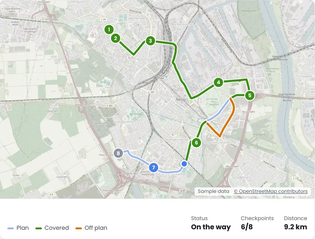
See positions, the covered stretches of the plan and checkpoints on the live screen.

Review
Go through the fleet summary, vehicle traces and checkpoint results of past drives.
Automatic
Start a multi-vehicle plan from an area.
Pick a country and city, or draw or upload the area. Set 2, 4 or 6 vehicles and a target in km or hours, and AnyRoute generates one route per vehicle inside it.
- Your prioritiesRoad classes, population priority, start points and mandatory stops.
- Up to 8 shiftsDivide the target into shifts when the day needs it.
- Still yours to editAfter generating, edit the waypoints, lock them and export.
Parameters
Tune the plan down to the road class.
Automatic planning follows your settings: road class mix, population priority, point spacing, vehicle overlap and more. Start from the defaults and change only what your area needs.
Population tiers
See where people are. Decide what counts as dense.
The population layer colors the map in three tiers: red for the highest population, yellow for medium, green for low. You set the cut-offs yourself. Move the sliders and the map follows.
Manual
Keep control of the daily plan.
Click the map to place waypoints and the route follows public roads. Drag, add or replace points to fine-tune it without generating it again.
Google routing uses the same flow and can integrate with Google Maps. A motorcycle profile uses it too.
Auto waypoints
New waypoints, same road.
Once a route is approved, regenerate its waypoints along the line at the interval you choose, in metres or kilometres. The road line does not move.
Waypoint access audit
Catch the waypoints a car can't reach.
Load a GPX or KML file and every waypoint is checked at its exact spot. Points on a public drivable road stay green. Private or closed roads, off-road points and spots off the car path turn red, and nothing moves on its own.
Import, export and handover
From a file to the driver.
Bring in a route as GPX, KML or ITN. Send it out as the file each navigation app expects, or save it with a short code and reopen it later.
- Driver GPX and TomTom ITNWaypoint files for navigation on the road.
- Main route KML and track GPXGeometry to check on a map and to archive.
- Zip by vehicleEvery file for a vehicle in one package.
- Navigation codeLoad the route into the mobile app with a code.
Split routes
One long route, several drivers.
Divide a route into up to 8 parts, or pick a boundary yourself on the map. Each part becomes its own driver file.
Transfer routes
Getting from A to B is part of the plan.
Enter an origin and a destination to see alternative routes between them. Pick one, load it onto a vehicle, then edit or export it right away.
Also in the app
Checks before anyone drives.
Shared route check
An algorithm measures the road two vehicles drive in common, so overlap shows before the day starts.
Same-road re-traversal
Shows whether the same vehicle drove a road it had already driven.

Simulation
Play the route on the map before anyone drives it.
Mandatory points
Pick the highways, POIs or hotspots a vehicle has to pass.
Help assistant
Ask how, right inside the app.
An AI chatbot answers how-to questions about AnyRoute, from drawing a route to live tracking and history.
Live tracking
See where vehicles are and how the plan is going.
Follow vehicles on the live map with positions from the navigation app. The screen updates as data comes in.
- Vehicle cardsSpeed, position accuracy and working status.
- CheckpointsPassed, next, waiting and skipped.
- On the planCompleted stretches in green, the off-plan trace in orange.
History and performance
Close the day with the full picture.
Live and finished drives sit in the same history screen, so you can see at the end of the day how far each plan got.
Fleet summary
All vehicles of a day at a glance.
Vehicle trace
The path a selected vehicle drove.

Checkpoint results
What was passed and what was skipped.
Good to know
What it does and doesn't do.
Coverage in AnyRoute means the planned road was driven. It is not a measure of signal quality.
- Does it cover every street automatically?
- No. Automatic planning builds the main route from your km or time target and road priorities. Missing stretches can be completed by hand.
- Can a plan go over the km target?
- Yes. Mandatory points are always kept, so the target can be exceeded.
- How does a route reach the driver?
- With a navigation file, a shared link or a mobile navigation code.
Run your next field day from one platform.
Tell us how your team plans drive tests today. We show you how it looks in AnyRoute.